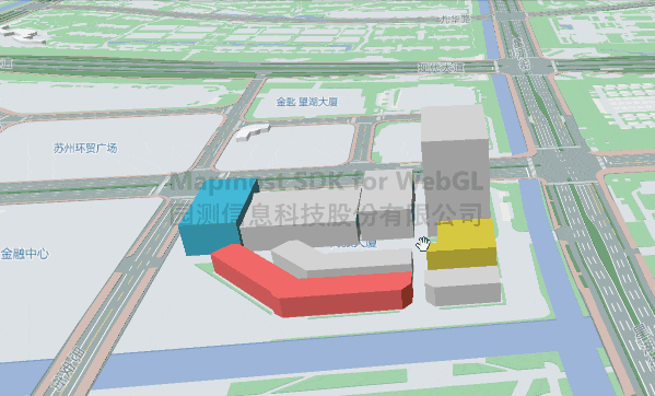
图层要素分层设色
依据要素属性自定义设置渲染颜色。
<!DOCTYPE html>
<html>
<head>
    <meta charset="utf-8"/>
    <title>图层要素分层设色</title>
    <meta name="viewport" content="initial-scale=1,maximum-scale=1,user-scalable=no"/>
    <style>
        body {
            margin: 0;
            padding: 0;
        }

        #map {
            position: absolute;
            top: 0;
            bottom: 0;
            width: 100%;
        }
    </style>
    <script src="https://delivery.mapmost.com/cdn/sdk/webgl/v9.0.0/mapmost-webgl-min.js"></script>
</head>
<body>
<div id="map"></div>
<script>
    let map = new mapmost.Map({
        container: 'map',
        style: "<your style url>",
        center: [120.72541613154851, 31.31171803927643],
        zoom: 14,
        pitch:60,
        userId: '***', // 授权码
    });

      map.on('load', function () {

        map.addSource("building0",{
            "type": "geojson",
            "data": {
                "type": "FeatureCollection",
                "name": "ss",
                "crs": { "type": "name", "properties": { "name": "urn:ogc:def:crs:OGC:1.3:CRS84" } },
                "features": [
                    { "type": "Feature", "properties": { "objectid": 15023, "ztykgd": 13.5 }, "geometry": { "type": "MultiPolygon", "coordinates": [ [ [ [ 120.714434435827997, 31.323480622652106 ], ...... ] ] ] } },
                    { "type": "Feature", "properties": { "objectid": 16241, "ztykgd": 22.3 }, "geometry": { "type": "MultiPolygon", "coordinates": [ [ [ [ 120.714745019318983, 31.324461294684102 ],  ...... ] ] ] } },
                    { "type": "Feature", "properties": { "objectid": 16272, "ztykgd": 22.3 }, "geometry": { "type": "MultiPolygon", "coordinates": [ [ [ [ 120.713963383795715, 31.32438284911829 ], ...... ] ] ] } },
                    { "type": "Feature", "properties": { "objectid": 16647, "ztykgd": 13.5 }, "geometry": { "type": "MultiPolygon", "coordinates": [ [ [ [ 120.715311160287015, 31.323570314124812 ],  ...... ] ] ] } },
                    { "type": "Feature", "properties": { "objectid": 21694, "ztykgd": 21.5 }, "geometry": { "type": "MultiPolygon", "coordinates": [ [ [ [ 120.715364774041021, 31.323835315535778 ],  ...... ] ] ] } },
                    { "type": "Feature", "properties": { "objectid": 22885, "ztykgd": 18.1 }, "geometry": { "type": "MultiPolygon", "coordinates": [ [ [ [ 120.713977078392915, 31.32437625343384 ],  ...... ] ] ] } },
                    { "type": "Feature", "properties": { "objectid": 22903, "ztykgd": 68.9 }, "geometry": { "type": "MultiPolygon", "coordinates": [ [ [ [ 120.715648756035222, 31.324459183818348 ],  ...... ] ] ] } },
                    { "type": "Feature", "properties": { "objectid": 23327, "ztykgd": 13.5 }, "geometry": { "type": "MultiPolygon", "coordinates": [ [ [ [ 120.714522302274005, 31.323708997003887 ],  ......] ] ] } }
                ]
            }
        })

        map.addLayer({
            "id": "house",
            'type': 'fill-extrusion',
            "source": "building0",
            "layout": {},
            "paint": {
                'fill-extrusion-color': [
                    'match',
                    ['get', 'objectid'], // 根据 geojson 中的 objectid 设置颜色
                    15023,
                    '#e55e5e',
                    16272,
                    '#3bb2d0',
                    21694,
                    '#d0c139',
                    /* other */ '#ccc'
                ],
                "fill-extrusion-height": ["get", "ztykgd"], // 建筑拉伸高度
            }
        })
      })
</script>
</body>
</html>