Product features
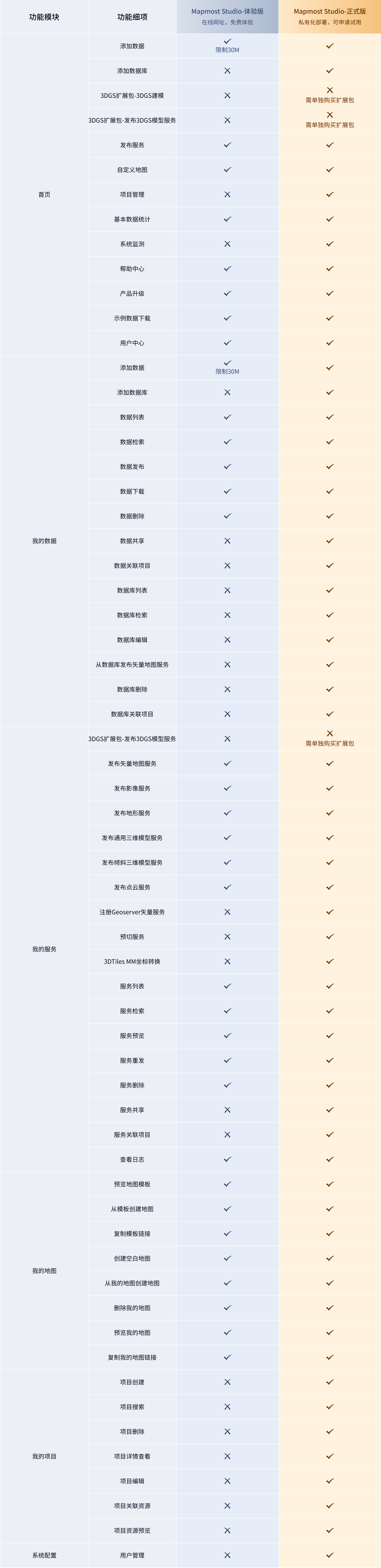
1. Feature list
2. Capability boundary
2.1. Supported data formats
2.1.1. Vector data
- Supports vector data in Shapefile format. SHP data (Shapefile) is a commonly used vector data format in the GIS field. It was developed by Esri and is used to store spatial location and attribute information of geographical elements such as points, lines, and surfaces. It is actually composed of multiple files such as.shp (geometry),.shx (index),.dbf (attribute table), and.prj (projection information). It has the characteristics of wide compatibility and simple structure, and is one of the most basic data formats in geospatial analysis.
- Support PostgreSQL database (including PG-like database)
- Spatial reference supports EPSG:4326, EPSG:3857, EPSG:4528, EPSG:4490, EPSG:4579, Suzhou 2000 coordinate system
2.1.2. Image data
Supports image data in TIFF and TIF formats. Image data refers to image information of the earth's surface or other objects captured by various imaging devices (such as satellites, aircraft, drones, etc.).
2.1.3. Terrain data
Supports terrain data in TIF format. Terrain data refers to data that uses numbers, characters, etc. to represent the terrain characteristics of the earth's surface, such as elevation, slope, aspect, etc. It mainly includes digital elevation model (DEM), digital terrain model (DTM) and other formats.
2.1.4. Universal 3D model
- Supports 3D models in OBJ format. OBJ is a 3D model file format developed by Wavefront Technologies for storing 3D geometric data.
- Supports 3D models in FBX format. FBX (FilmBox) is a 3D file format developed by Autodesk and is widely used in fields such as 3D modeling, animation and game development. The FBX format supports polygonal game models, curves, surfaces, point group materials, and all major 3D data elements.
- Supports 3D models in GLB/GLTF format. GLB/GLTF are 3D model formats defined by the Khronos Group and support various features required by modern 3D engines and applications, such as PBR materials, animations and bones.
2.1.5. Tilt 3D model
Supports OSGB data. The OSGB (Open Scene Graph Binary) file format is a 3D geospatial data file format that is widely used to store and transmit large-scale three-dimensional geographic information.
2.1.6. Laser point cloud data
Supports laser point cloud data in LAS format. LAS is a data set composed of a large number of three-dimensional coordinate points (X, Y, Z), which may include additional attributes such as color (RGB), intensity (Intensity), and normal (Normal).
2.1.7. 3DGS model
Supports laser point cloud data in the splat/ply format. The splat/ply format is a file format used to store 3DGS model data. It can record the vertices, colors, normal vectors and patch information of the model.
2.2. Supported service types
2.2.1. Vector tile service
Supports publishing encrypted MVT vector tile map service. MVT vector tile service is a technology for efficiently transmitting geospatial data. It transmits raw geographic data (points, lines, polygons, etc.) rather than pre-rendered images.
- Provides high flexibility and interactivity.
- Clients can dynamically render data and adjust styles.
- Based on Protocol Buffers (protobuf), it has compact representation and efficient parsing performance.
- Self-developed encrypted vector map service release technology to ensure data security.
2.2.2. Imaging services
Supports publishing WMTS and TMS map services, and outputs them as PNG or JPG format image files.
- Simple and intuitive, suitable for browsing and viewing directly in the 2D engine.
- The data is easy to load and display, making it suitable for static map applications.
2.2.3. Terrain services
Supports the release of Terrain-RGB and Quantized-Mesh services, providing triangulation data describing the surface relief, which is the basic data of the 3D engine. The following two standards are supported:
Terrain-RGB (for Mapmost SDK for WebGL)
- Encode elevation data using RGB color space.
- Supports efficient transmission and compression while maintaining elevation data accuracy.
- Typically used as grid tiles, suitable for fast loading and display.
Quantized-Mesh (for Mapmost SDK for UE5)
- A format for efficient storage and transmission of 3D terrain data.
- Through quantized regular grids and compression algorithms, rapid loading and rendering of large-scale terrain data is achieved.
2.2.4. General 3D model service
Supports the publication of general 3D model slicing services, and the service format is 3DTiles. 3DTiles is an open standard for efficient transmission and rendering of large-scale three-dimensional geospatial data.
- Based on the hierarchical tile structure, it supports dynamic loading of multiple levels of details (LOD).
- Consists of an index (metadata in JSON format) and content, and indexes can nestly reference other indexes.
2.2.5. Oblique 3D model service
Supports publishing oblique 3D model slicing services, and the service format is 3DTiles. 3DTiles is an open standard for efficient transmission and rendering of large-scale three-dimensional geospatial data.
- Based on the hierarchical tile structure, it supports dynamic loading of multiple levels of details (LOD).
- Consists of an index (metadata in JSON format) and content, and indexes can nestly reference other indexes.
2.2.6. Point cloud service
Supports publishing point cloud services, and the service format is 3DTiles. 3DTiles is an open standard for efficient transmission and rendering of large-scale three-dimensional geospatial data.
- Based on the hierarchical tile structure, it supports dynamic loading of multiple levels of details (LOD).
- Consists of an index (metadata in JSON format) and content, and indexes can nestly reference other indexes.
2.2.7. 3DGS model service
Supports the release of self-developed format 3DGS model services, and the service adopts a hierarchical tile organizational structure.
- Based on the global unified tile grid division, tile positions are strictly aligned with absolute geographical coordinates.
- Adopting a hierarchical organizational structure, it naturally supports on-demand loading and dynamic switching of multiple levels of detail (LOD).