Map
MapThe object is the map on the page. It gives you access to methods and properties for interacting with the map’s styles and layers, responding to events, and manipulating the user’s perspective with the camera. Developer createdMapAfter the object, pass the specifiedcontainerand other optional parameters,Mapmost SDK Lite will initialize the map on the page and returnMapobject.
new mapmost.Map (options: Object)
parameter
| name | type | describe | ||||||||||||||||||||||||||||||||||||||||||||||||||||||||||||||||||||||||||||||||||||||||||||||||||||||||||||||||||||
|---|---|---|---|---|---|---|---|---|---|---|---|---|---|---|---|---|---|---|---|---|---|---|---|---|---|---|---|---|---|---|---|---|---|---|---|---|---|---|---|---|---|---|---|---|---|---|---|---|---|---|---|---|---|---|---|---|---|---|---|---|---|---|---|---|---|---|---|---|---|---|---|---|---|---|---|---|---|---|---|---|---|---|---|---|---|---|---|---|---|---|---|---|---|---|---|---|---|---|---|---|---|---|---|---|---|---|---|---|---|---|---|---|---|---|---|---|---|---|
| options | Object | Requiredparameter
|
let map = new mapmost.Map({
    container: 'map', // elementalid
    style: "https://www.mapmost.com/cdn/styles/sample_data.json", // map styleURL
    center: [120.72541613154851, 31.31171803927643], // starting coordinates
    zoom: 14, // Starting zoom level
    userId: '***' // Authorization code,This parameter is fromv3.1.0Be sure to add it at the beginning of the version
});
refer to Example。
method
addArcGISDynamicLayer
Support loadingArcGISDynamic layers
parameter
| name | type | describe | ||||||||||||||||||||||||
|---|---|---|---|---|---|---|---|---|---|---|---|---|---|---|---|---|---|---|---|---|---|---|---|---|---|---|
| id | String | RequiredLayer uniqueID。 | ||||||||||||||||||||||||
| source | Object | Requiredparameter
| ||||||||||||||||||||||||
| project | String | RequiredThe coordinate system name of the raster service. Supported by default"3857"、"4326"、"4490"and"4528",Other coordinate systems need to be passed in through customization. |
Case
map.on('load', function() {
    map.addArcGISDynamicLayer({
        id: 'layer',
        project:'<myproject>', //coordinate system
        source: {
            url: 'https://IP/***/MapServer', // Service address
            format: 'PNG', // Image format, default isPNG
            layers: 'show:0', // Displayed layers
            transparent: true, // Whether the image is transparent, the default is true
        },
    });
});
refer to Example。
addControl
WillIControlAdd to map, callcontrol.onAdd(this),Need on map style Add this control after loading is complete.
parameter
| Name | Type | Default | Description |
|---|---|---|---|
| control | IControl | Requiredto add IControl。 | |
| position | string | top-right | OptionalThe location on the map where the control will be added. Valid values are " " and defaults to string type "top-left"、"top-right"、"bottom-left"、"bottom-right"、"top-right"。 |
Case
map.on('load', function() {
    // Adds zoom and rotation controls to the map.
    map.addControl(new mapmost.NavigationControl());
});
addImage
Add image resources to the map style. available asicon-image, background-pattern, fill-patternandline-patternShow on the map. ifspriteThere is not enough space to add this image and an error will be reported.
map.addImage(id,image,options)
parameter
| name | type | describe | ||||||||||||
|---|---|---|---|---|---|---|---|---|---|---|---|---|---|---|
| id | String | RequiredImage onlyID | ||||||||||||
| image | String | RequiredImage format supportHTMLImageElement、ImageBitmap、StyleImageInterface、ImageData、{width: number, height: number, data: (Uint8Array | Uint8ClampedArray)} | ||||||||||||
| options | Object | Optionalparameter
|
Case
// If the map style sprite is not already includedIDfor "cat" images,
// convert image "cat-icon.png" ofIDnamed "cat" Added to a map style sprite.
map.loadImage('path/test1.svg.png', function(error, image) {
   if (error) throw error;
   if (!map.hasImage('cat')) map.addImage('cat', image);
});

// Add one to use `icon-text-fit` stretchable image of
// In this case, the image size is 600*400 pixels.
map.loadImage('path/test2.png', function(error, image) {
   if (error) throw error;
   if (!map.hasImage('border-image')) {
     map.addImage('border-image', image, {
         content: [16, 16, 300, 384], // Place the text on the left half of the image to avoid 16 pixel boundaries
         stretchX: [[16, 584]], // horizontal stretch 16 Everything except pixel borders
         stretchY: [[16, 384]], // vertical stretch 16 Everything except pixel borders
     });
   }
});
// Define a source and use it to create a new layer
map.addSource('state-data', {
type: 'geojson',
data: 'path/to/data.geojson'
});

map.addLayer({
id: 'states',

// Quoting the definition above GeoJSON source
// and don’t need a `source-layer`
source: 'state-data',
type: 'symbol',
layout: {

// Set label content to
// characteristic `name` property
"text-field": ['get', 'name']
}
});
addLayer-basic
Add layers to your map style, including background、circle、line、fill、symbol、raster、fill-extrusion、heatmap and hillshadetype.
parameter
| name | type | describe | ||||||||||||||||||||||||||||||||||||
|---|---|---|---|---|---|---|---|---|---|---|---|---|---|---|---|---|---|---|---|---|---|---|---|---|---|---|---|---|---|---|---|---|---|---|---|---|---|---|
| layer | Object | Requiredparameter
| ||||||||||||||||||||||||||||||||||||
| beforeId | String | Optionalon existing layer ID Insert the new layer before so that the new layer appears underneath the existing layer. If this parameter is not specified, the layer will be appended to the end of the layers array and displayed visually on top of all other layers. |
Case
// Add a vector source circle layer
map.addLayer({
id: 'points-of-interest',
source: {
type: 'vector',
url: 'url'
},
'source-layer': 'poi_label',
type: 'circle',
paint: {
// MapMostStyle specification drawing properties
},
layout: {
// MapMostStyle specification layout properties
}
});
// Define a source and use it to create a new layer
map.addSource('state-data', {
type: 'geojson',
data: 'path/to/data.geojson'
});

map.addLayer({
id: 'states',
// Quoting the definition above GeoJSON source
// and don’t need a `source-layer`
source: 'state-data',
type: 'symbol',
layout: {
// Set label content to
// characteristic `name` property
"text-field": ['get', 'name']
}
});
// Add a new symbol layer before the existing layer
map.addLayer({
    id: 'states',
    // Reference an already defined source
    source: 'state-data',
    type: 'symbol',
    layout: {
    // Set label content to
    // characteristic `name` property
    "text-field": ['get', 'name']
    }
// in existing `cities` Add layer before layer
}, 'cities');
addLayer-buildings
load3DArchitectural thematic layer. Users can use two-dimensionalGeoJSONData construction3Dmodel, or by loading a prefabricated building model to generate a custom3DThematic layer.
parameter
| name | type | describe | |||||||||||||||||||||||||||||||||||||||||||||||||||||||||||||||||||||||||||||||||||||||||||||||||
|---|---|---|---|---|---|---|---|---|---|---|---|---|---|---|---|---|---|---|---|---|---|---|---|---|---|---|---|---|---|---|---|---|---|---|---|---|---|---|---|---|---|---|---|---|---|---|---|---|---|---|---|---|---|---|---|---|---|---|---|---|---|---|---|---|---|---|---|---|---|---|---|---|---|---|---|---|---|---|---|---|---|---|---|---|---|---|---|---|---|---|---|---|---|---|---|---|---|---|---|
| layer | Object | Requiredparameter
| |||||||||||||||||||||||||||||||||||||||||||||||||||||||||||||||||||||||||||||||||||||||||||||||||
| beforeId | String | Optionalon existing layer ID Insert the new layer before so that the new layer appears underneath the existing layer. If this parameter is not specified, the layer will be appended to the end of the layers array and displayed visually on top of all other layers. |
- options.lights Ambient light parameter configuration example
  {
      id: 'light1',   // light sourceid
      type:'ambient', // natural light
      color:0xffffff, // Light source color
      intensity:300   // Light intensity
  },{
      id: 'light2',
      type:'point',   // point light source
      color:0xffffff,
      intensity:0.1,
      position:[0,0,0] // The position of the light source in the scene
  },{
      id: 'light3',
      type:'spot',    // spotlight light source
      color:0xffffff,
      intensity:0.1,
      position:[0,0,0],
  },{
      id: 'light4',
      type:'directional', // parallel light/Directional light
      color:0xffffff,
      intensity:0.3,
      position:[0.5, 0, 0.866],
  },{
      id: 'light5',
      type: 'hemisphere',     // hemispheric light source
      skyColor: 0xccccff,     // The color of light emitted from the sky
      groundColor: 0xff0322,  // Color of light emitted from the ground
      intensity: 2,
      position: [0, 50, 100]
  }
Case
(1)According to the buildingGeoJSONbuild
 let op = {
     id: 'b',
     type: 'buildings',
     proj: '4326',
     data: response,
     images: ['../files/images/top.png', '../files/images/wall.png'],
     defaultLights:false,
     heightProp: 'ztykgd',
     lights: [
         {
             id: 'light1',
             type: 'ambient',
             color: 0xccccff,
             intensity: 2
         }, {
             id: 'light2',
             type: 'directional',
             color: 0xffffff,
             intensity: 0.25,
             position: [0, 8000, 10000]
         },
     ],
     material:{
         top:{
             opacity:0.8
         },
         wall:{
             opacity:0.8
         }
     },
 };
 map.addLayer(op);
refer to Example。
(2)Built from an architectural model
Models need to be made according to a specific process based on vector data.
Model loading test:
- Test equipment: Lenovo R9000P(The graphics card is GTX 3070);
- Model loading test: based on Nanjing165797The model constructed from building data is stable at58fpsabove.
 let op = {
  id: 'sipsd',
  type: 'buildings',
  images: ['./top.png', './wall_reverse.png'], // Ceiling and wall textures
  models: models_obj,
  defaultLights: false,
  center: [120.7464153334825, 31.333162198642274],
  lights: [
    {
      id: 'light1',
      type: 'ambient',
      color: 0xccccff,
      intensity: 2
    }, {
      id: 'light2',
      type: 'directional',
      color: 0xffffff,
      intensity: 0.25,
      position: [0, 8000, 10000]
    },
  ]
};

map.addLayer(op);
refer to Example。
addLayer-geoVideo
After loading the 3D video fusion layer, the user can perform a series of interactive operations on the video object.
parameter
| name | type | describe | ||||||||||||||||||||||||||||||||||||||||||||||||||||||||||||||||||||||||||||||||||||||||||||||
|---|---|---|---|---|---|---|---|---|---|---|---|---|---|---|---|---|---|---|---|---|---|---|---|---|---|---|---|---|---|---|---|---|---|---|---|---|---|---|---|---|---|---|---|---|---|---|---|---|---|---|---|---|---|---|---|---|---|---|---|---|---|---|---|---|---|---|---|---|---|---|---|---|---|---|---|---|---|---|---|---|---|---|---|---|---|---|---|---|---|---|---|---|---|---|---|---|
| layer | Object | Requiredparameter
| ||||||||||||||||||||||||||||||||||||||||||||||||||||||||||||||||||||||||||||||||||||||||||||||
| beforeId | String | Optionalon existing layer ID Insert the new layer before so that the new layer appears underneath the existing layer. If this parameter is not specified, the layer will be appended to the end of the layers array and displayed visually on top of all other layers. |
GeoVideoLayermethod Please refer to the specific detailsdocument。
addLayer-heatmap-3d
Load point data and generate3DHeatmap layer.
parameter
| name | type | describe | |||||||||||||||||||||||||||||||||||||||||||||||||||||||||||||||||||||||||||||||||||||||||||||||
|---|---|---|---|---|---|---|---|---|---|---|---|---|---|---|---|---|---|---|---|---|---|---|---|---|---|---|---|---|---|---|---|---|---|---|---|---|---|---|---|---|---|---|---|---|---|---|---|---|---|---|---|---|---|---|---|---|---|---|---|---|---|---|---|---|---|---|---|---|---|---|---|---|---|---|---|---|---|---|---|---|---|---|---|---|---|---|---|---|---|---|---|---|---|---|---|---|---|
| layer | Object | Requiredparameter
| |||||||||||||||||||||||||||||||||||||||||||||||||||||||||||||||||||||||||||||||||||||||||||||||
| beforeId | String | Optionalon existing layer ID Insert the new layer before so that the new layer appears underneath the existing layer. If this parameter is not specified, the layer will be appended to the end of the layers array and displayed visually on top of all other layers. |
Things to note: Before starting the program, you need to passcdnintroduceheatmap.jslibrary.
Case
<script src="heatmap.js"></script> //Download address:https://cdnjs.cloudflare.com/ajax/libs/heatmap.js/2.0.2/heatmap.js
 let op = {
                id: '3d-heatmap-layer',
                type: 'heatmap-3d',
                data: dataPoints,//dataPoints = [[lon,lat,value]],The parameters are longitude, latitude, and attribute values.
                width: 256,//Heat map canvas width, default256
                height: 256,//Heat map canvas height, default256
                heightRatio: 200,//3DHeat map stretch height, default200
                // proj:"3857",//Coordinate system support'3857'and'4326',default'4326'
                blur: 0.85,//[0,1] Optional parameters default = 0.85 ,Applies to all point data. The higher the coefficient, the smoother the gradient. The default is0.85
                radius: 6, //Radius of each data point, default6
                gradient: {
                    '0.1': 'rgb(0,102,255)',
                    '0.2': 'rgb(102,255,255)',
                    '0.3': 'rgb(102,255,153)',
                    '0.4': 'rgb(125,255,0)',
                    '0.5': 'rgb(255,255,0)',
                    '0.6': 'rgb(255,204,0)',
                    '0.7': 'rgb(255,128,0)',
                    '0.8': 'rgb(255,102,0)',
                    '0.9': 'rgb(255,0,0)',
                }, //A ribbon object representing a gradient,If not set, the default style will be used
            };

            map.addLayer(op);
refer to Example 1 3Dheat map。
refer to Example 2 3DReal-time heat map。
addLayer-model
Load a 3D manual model, and the user can perform a series of interactive operations on the model, supporting gltf、glb、obj and fbx Format model loading.
parameter
| name | type | describe | |||||||||||||||||||||||||||||||||||||||||||||||||||||||||||||||||||||||||||||||||||||||||||||||||
|---|---|---|---|---|---|---|---|---|---|---|---|---|---|---|---|---|---|---|---|---|---|---|---|---|---|---|---|---|---|---|---|---|---|---|---|---|---|---|---|---|---|---|---|---|---|---|---|---|---|---|---|---|---|---|---|---|---|---|---|---|---|---|---|---|---|---|---|---|---|---|---|---|---|---|---|---|---|---|---|---|---|---|---|---|---|---|---|---|---|---|---|---|---|---|---|---|---|---|---|
| layer | Object | Requiredparameter
| |||||||||||||||||||||||||||||||||||||||||||||||||||||||||||||||||||||||||||||||||||||||||||||||||
| beforeId | String | Optionalon existing layer ID Insert the new layer before so that the new layer appears underneath the existing layer. If this parameter is not specified, the layer will be appended to the end of the layers array and displayed visually on top of all other layers. |
ModelLayermethod Please refer to the specific detailsdocument。
Object3Dmethod
setCoords: (LngLatLike) (required) Set the spatial coordinates of the geographical location of the 3D model. The coordinate system is used by default.CGCS2000coordinate(EPSG:4490)。setScale: (Number/Object) (optional) Set the zoom ratio of the 3D model on the map, including alongX、Y、ZThe ratio of three-axis scaling,{x:1, y:1, z:1}。setRotation: (Number/Object) (optional) Set the spatial rotation matrix of the three-dimensional model on the map, including rotating theX、Y、ZThe angle of three-axis rotation, expressed in degrees.setTranslation: (Number/Object) (optional) Set the spatial translation matrix of the three-dimensional model on the map, includingX、Y、ZThe distance of three-axis translation, expressed in meters.followPath: ({path: LineGeometry, duration: Number},cb) (optional) To set the 3D model to move along a polyline in ground space, you need to enter the polyline path along the movement and the playback speed of the movement animation.durationIn milliseconds, the animation is executed after execution.cbcallback function.stop: (optional) Stops the animation of a 3D model moving in ground space.addFrame: (color:String,thresholdAngle:Number) (optional) Add a wireframe of the model in the 3D scene. parameterthresholdAngleOnly if the angle between the normals of adjacent faces(in degrees)When this value is exceeded, the edge will be displayed. Default value= 1Spend.removeFrame: (optional) Removes the wireframe of a model from a 3D scene.showFrame: (optional) Displays the model wireframe that has been added to the 3D scene.hideFrame: (optional) Hide the wireframe of the model that is displayed in the 3D scene.
Model loading test:
- Test Equipment: UseDell xps15Laptop (graphics card is GTX 1050Ti);
- White model loading test: the loading limit is approximately1.87GWhite model, number of vertices62,831,216,Number of sides25,045,574;
- Precision mold loading test: less than1G,Loading performance is affected by model maps.
Model loading suggestions:
- Model format: Recommendedgltf/glbformat model;
- Model size: It is recommended to split the model into multiple smaller models for loading;
- Model material: It is recommended to use standard material (Standard),The map name and material name of the standard material must be consistent; if a multi-dimensional sub-material is used, the number of multi-dimensional sub-materials must not exceed13, the map name and material name of the standard material contained in the multi-dimensional sub-material must be consistent.
Case
    let models_obj = [{
            type: 'glb',
            url: "../files/models/jinji_plaza_eastern_door_building.glb",
            // dracoUrl:"http://******:8008/gltfDraco/"  //Supports loading of compressed models. The resources have been uploaded and can be used on demand. The absolute path needs to be passed in when using.
        }];

    let options = {
        id: 'model_id',
        type: 'model',
        models: models_obj,
        center: [120.67727020663829, 31.31997024841401],
        callback: function (group, layer) {
            // aroundyaxis rotation90Spend
            // group.setRotation({y:90});

            // x/y/zMagnify each axis2times
            // group.setScale(2);

            // Add the model to the layer
            // layer.addModel(models_obj,[120.67727020663829, 31.31997024841401]);

            // Click
            // map.on('click',function(e){
            //  let intersect = layer.selectModel(e.point)[0];
            //  if (intersect) {
            //     const obj = intersect.object;
            //    // TODO more
            //  }
            // })
         }
    };
    map.addLayer(options);
refer to Example。
add3dTilesLayer
load in map3DTilesOblique model of format.
parameter
| name | type | describe | ||||||||||||||||||||||||||||||||||||||||||||
|---|---|---|---|---|---|---|---|---|---|---|---|---|---|---|---|---|---|---|---|---|---|---|---|---|---|---|---|---|---|---|---|---|---|---|---|---|---|---|---|---|---|---|---|---|---|---|
| layer | Object | Requiredparameter
| ||||||||||||||||||||||||||||||||||||||||||||
| beforeId | String | Optionalon existing layer ID Insert the new layer before so that the new layer appears underneath the existing layer. If this parameter is not specified, the layer will be appended to the end of the layers array and displayed visually on top of all other layers. |
Model loading test:
- Test equipment: using LenovoR9000PNotebook (memory:32G,Graphics card:GTX 3070);
- Model loading test: area 52.857square kilometers, file size 49.7G;
- Note: Not supported yetcmptFormat
Case
 //Create an initialized identity matrix
let matrix = new window.mapmost.Matrix4();
//Add translation rotation transformation
let matrix4 = matrix.translate([0, 0, 200]).rotateX(Math.PI / 2);
// load3DTiles
map.add3dTilesLayer(
    {
        id: 'tile-3d-layer',
        data: TILESET_URL,
        lights: [
            {
                type: 'ambient',//ambient light
                color: [255, 255, 255],
                intensity: 0.01
            },
            // {
            //   type: 'point',//point light source
            //   color: [255, 0, 0],
            //   intensity: 0.1,
            //   position: [120, 31, 100]
            // },
            // {
            //   type: 'directional',//Directional light
            //   color: [255, 255, 255],
            //   intensity: 0.1,
            //   direction: [120, 31, 1000]
            // }
        ],
        transform: matrix4,
        // loadOptions:{
        //     draco:{//Used to load tilt data containing compressed models offline or on the intranet.
        //      libsUrl:"http://******:8008/draco",//The resource has been uploaded and can be used on demand. You need to pass in the absolute path when using it.
        //      }
        // }
    }
)
// Remove3DTiles
map.removeLayer('tile-3d-layer')
refer to Example 1。 refer to Example 2。 refer to Example three。
addMigrationLayer
The migration map displays the migration trajectory and magnitude of the data dynamically and in real time on the map, allowing you to visually view the source and destination of the data.
parameter
| name | type | describe | ||||||||||||||||||||
|---|---|---|---|---|---|---|---|---|---|---|---|---|---|---|---|---|---|---|---|---|---|---|
| options | Object | Requiredparameter
|
Case
<script src="https://unpkg.com/@turf/turf@6/turf.min.js"></script>
 // data

let data = [
  {
    coords: [[120.70254950835465, 31.34452333816192], [120.72899820084962, 31.339048513540533]],
  },
  {
    coords: [[120.71146083590128, 31.328411691268002], [120.72899820084962, 31.339048513540533]],
  },
  {
    coords: [[120.6919983801705, 31.330883608912274], [120.72899820084962, 31.339048513540533]],
  },
  {
    coords: [[120.69473931280976, 31.347288081092003], [120.72899820084962, 31.339048513540533]],
  }];

let a =  map.addMigrationLayer({
    id:'test',
    data:data,
    pointImgUrl:'./point.png'
})

map.on('click',function(){
    a.remove();
})
refer to Example。
addOnlineVideo
Load live video on the map, supporthlsvideo streaming andflvVideo streaming.
parameter
| name | type | describe | ||||||||||||||||||
|---|---|---|---|---|---|---|---|---|---|---|---|---|---|---|---|---|---|---|---|---|
| options | Object | Requiredparameter
|
Case
    // Add 2D flat video
    map.addOnlineVideo({
        id: 'test',  // with layersidSimilar, need unique
        type: 'hls', //  hlsLive video streaming type
        coordinates: [    // Corner point coordinate array: starting from the upper left corner of the video, clockwise;CGCS2000coordinate
            [120.621, 31.295],
            [120.623, 31.295],
            [120.623, 31.293],
            [120.621, 31.293],
        ],
        url: 'https://sf1-hscdn-tos.pstatp.com/obj/media-fe/xgplayer_doc_video/hls/xgplayer-demo.m3u8'  // hlsvideourl
    });
    // Add stereoscopic video
    map.addOnlineVideo({
        id: 'test-3d',  // with layersidSimilar, need unique
        type: 'flv', //  flvLive video streaming type
        coordinates: [    // Corner point coordinate array: starting from the upper left corner of the video, clockwise;CGCS2000coordinate
            [120.621, 31.296, 100],
            [120.623, 31.296, 100],
            [120.623, 31.296, 0],
            [120.621, 31.296, 0],
        ],
        url: 'https://sf1-hscdn-tos.pstatp.com/obj/media-fe/xgplayer_doc_video/flv/xgplayer-demo-720p.flv',  // flvvideourl
    });
    // Add stereoscopic video to add feathering effect
    map.addOnlineVideo({
        id: 'test-3d-mask',  // with layersidSimilar, need unique
        type: 'flv', //  flvLive video streaming type
        coordinates: [    // Corner point coordinate array: starting from the upper left corner of the video, clockwise;CGCS2000coordinate
            [120.624, 31.294, 100],
            [120.626, 31.294, 100],
            [120.626, 31.294, 0],
            [120.624, 31.294, 0],
        ],
        mask: "../example_data/images/mask.png",
        url: 'https://sf1-hscdn-tos.pstatp.com/obj/media-fe/xgplayer_doc_video/flv/xgplayer-demo-720p.flv',  // flvvideourl
    });
   // Remove video
    map.removeOnlineVideo('test')
refer to Example。
addRasterLayer2
Load raster services for various coordinate systems.
parameter
| name | type | describe | ||||||||||||||||||||||||||||||||||||||||||||||||||||||
|---|---|---|---|---|---|---|---|---|---|---|---|---|---|---|---|---|---|---|---|---|---|---|---|---|---|---|---|---|---|---|---|---|---|---|---|---|---|---|---|---|---|---|---|---|---|---|---|---|---|---|---|---|---|---|---|---|
| options | Object | Requiredparameter
|
zoomOffset illustrate
- First check the request tile level:0 of resolution Which of the following full resolutions corresponds to level。
The full resolution is as follows:
    [
        {
            level: 0,
            resolution: 156367.78906250003,
            scale: 590995186.1175001
        },
        {
            level: 1,
            resolution: 78183.89453125001,
            scale: 295497593.05875003
        },
        {
            level: 2,
            resolution: 39091.94726562501,
            scale: 147748796.52937502
        },
        {
            level: 3,
            resolution: 19545.973632812504,
            scale: 73874398.26468751
            },
        {
            level: 4,
            resolution: 9772.986816406252,
            scale: 36937199.132343754
        },
        {
            level: 5,
            resolution: 4886.493408203126,
            scale: 18468599.566171877
        },
        {
            level: 6,
            resolution: 2443.246704101563,
            scale: 9234299.783085939
        },
        {
            level: 7,
            resolution: 1221.6233520507815,
            scale: 4617149.891542969
        },
        {
            level: 8,
            resolution: 610.8116760253907,
            scale: 2308574.9457714846
        },
        {
            level: 9,
            resolution: 305.40583801269537,
            scale: 1154287.4728857423
        },
        {
            level: 10,
            resolution: 152.70291900634768,
            scale: 577143.7364428712
        },
        {
            level: 11,
            resolution: 76.35145950317384,
            scale: 288571.8682214356
        },
        {
            level: 12,
            resolution: 38.17572975158692,
            scale: 144285.9341107178
        },
        {
            level: 13,
            resolution: 19.08786487579346,
            scale: 72142.9670553589
        },
        {
            level: 14,
            resolution: 9.54393243789673,
            scale: 36071.48352767945
        },
        {
            level: 15,
            resolution: 4.771966218948365,
            scale: 18035.741763839724
        },
        {
            level: 16,
            resolution: 2.3859831094741826,
            scale: 9017.870881919862
        },
        {
            level: 17,
            resolution: 1.1929915547370913,
            scale: 4508.935440959931
        },
        {
            level: 18,
            resolution: 0.5964957773685456,
            scale: 2254.4677204799655
        },
        {
            level: 19,
            resolution: 0.2982478886842728,
            scale: 1127.2338602399827
        },
        {
            level: 20,
            resolution: 0.1491239443421364,
            scale: 563.6169301199914
        }
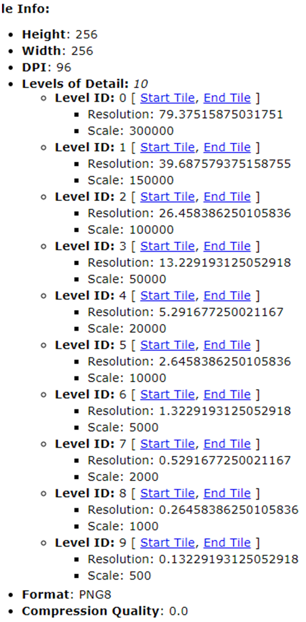
] - Then according to the level value setting zoomOffset offset. For example, in the picture below,level 0 The corresponding resolution is 79.375,with complete level middle grade 11 level is close, then set the parameters zoomOffset: -11。
- First check the request tile level:0 of resolution Which of the following full resolutions corresponds to level。
transformRequest illustrate
- byArcGISStatic slice resource file service as an example
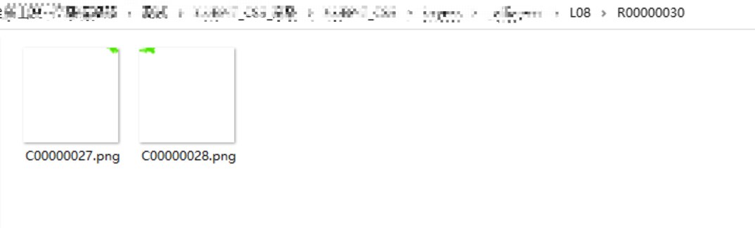
- The tile service request conversion function is as follows
    /* input parameters
       x:OK
       y:List
       z:Zoom level
       zoomOffset:offset
    */
    transformRequest: (x, y, z, zoomOffset) => {
        return url
          .replace('{x}', 'C' + x.toString(16).padStart(8, '0'))
          .replace('{y}', 'R' + y.toString(16).padStart(8, '0'))
          .replace('{z}', 'L' + String(z).padStart(2, '0'));
    }
Case
//load4490coordinate systemWMSServe
    let wms_option = {
        'id': 'wms-test-layer',
        'project': '4490',
        'source': {
            'tiles': [
                'IP:9000/geoserver/geoserver/sip/wms?SERVICE=WMS&VERSION=1.1.1&REQUEST=GetMap&FORMAT=image%2Fpng&TRANSPARENT=true&STYLES&LAYERS=sip%3Asip_road&SRS=EPSG%3A4326&WIDTH=256&HEIGHT=256&BBOX={bbox-epsg-4490}'
            ],
            'tileSize': 256
        }
    }
    map.addRasterLayer2(wms_option)
refer to Example 1。 refer to Example 2。 refer to Example three。
addSource
Add a data source to the map style.
map.addSource(id: string,options: Object)
parameter
| name | type | describe | |||||||||
|---|---|---|---|---|---|---|---|---|---|---|---|
| id | String | Requireddata source id。 | |||||||||
| options | Object | RequiredData source properties.
|
Case
// loadgeojsondata
map.addSource('sourceId', {
   type: 'geojson',
   data: {
       "type": "FeatureCollection",
       "features": [{
           "type": "Feature",
           "properties": {},
           "geometry": {
               "type": "Point",
               "coordinates": [
                   -76.53063297271729,
                   39.18174077994108
               ]
           }
       }]
   }
});
// loadgeojson url
map.addSource('some id', {
    type: 'geojson',
    data: 'path/data.geojson'
});
refer to Example。
addSourceView detailed usage source。
add3dTreesLayer
load in map3Dtree model.
parameter
| name | type | describe | ||||||||||||||||||||||||||||
|---|---|---|---|---|---|---|---|---|---|---|---|---|---|---|---|---|---|---|---|---|---|---|---|---|---|---|---|---|---|---|
| options | Object | Requiredparameter
|
Load test:
- Test equipment: using LenovoR9000PNotebook (memory:32G,Graphics card:GTX 3070);
- Loading test: million level(Use default parameters);
Case
// load3DTree
const sourceId = "tree-source"
map.addSource(sourceId, {
    type: 'geojson',
    data: '../example_data/treedata.geojson',//Point layer data, required attributesidandsize,insizeInclude"S"、"L"、"M"Represents small, medium and large tree models, such as"properties": { "id": 215, "size": "S" }
})
map.add3dTreesLayer({
    id: 'trees',
    source: sourceId,
    trunkColor: [219, 195, 154],
    crownColor: [175, 216, 142],
    crownMesh: 'crown.drc',
})
// Remove3DTree
map.remove3dTreesLayer("trees")
refer to Example。
cameraFlyTo
Change any combination of the camera’s center position, azimuth and tilt to dynamically change it along a curve and trigger a flight effect.
parameter
| name | type | describe | ||||||||||||||||||||||||||||
|---|---|---|---|---|---|---|---|---|---|---|---|---|---|---|---|---|---|---|---|---|---|---|---|---|---|---|---|---|---|---|
| options | Object | RequiredDescribes options for transition targets and dynamic effects.
|
Case
let options = {
    position: [120.65717659715574, 31.315522851509385, 500],
    pitch: 10,
    bearing: 90,
    duration: 2000,
    complete: function () {
        new mapmost.Marker()
            .setLngLat([120.65717659715574, 31.315522851509385])
            .addTo(map);
    }
}
map.cameraFlyTo(options);
refer to Example。
defineProject
Custom coordinate system, available foraddRasterLayer2The interface loads the corresponding raster service.
parameter
| name | type | describe |
|---|---|---|
| code | String | RequiredCoordinate system name, the name must be unique and not repeated. like "4236","3857","myProject" wait. |
| desc | String | Required Reference projection parameters for custom projections,Generally includes name, projection, conversion to WGS84 Coordinate system (three parameters, seven parameters), semi-major axis of ellipsoid, oblateness, origin latitude, central meridian, two standard latitudes, east offset, north offset and units, etc. Details can be obtained fromhttps://epsg.ioGet relevant references from the website. |
Case
    // Custom coordinate system
    map.defineProject("project0","+proj=tmerc +lat_0=0 +lon_0=120 +k=1 +x_0=40500000 +y_0=0 +ellps=GRS80 +units=m +no_defs +type=crs")
    // Load a custom coordinate system raster service
    let option = {
        'id': 'test-layer',
        'project': 'project0',
        'source': {
            'tiles': [
                '<your tiles url>'
            ],
            'tileSize': 256
        }
    }
    map.addRasterLayer2(option)
easeTo
Change the map’s center, zoom level, azimuth, and tilt angles in any combination with animated transitions between old and new values. The map retains its current values for any details not specified in the options.
parameter
| name | type | describe |
|---|---|---|
| options | Object | RequiredDescribes options for transition targets and dynamic effects. |
| eventData | Object/null | OptionalOther properties that need to be added to the event object triggered by this method. |
flyTo
center of map(Supports two-dimensional coordinates and three-dimensional coordinates)、Change any combination of zoom level, azimuth and tilt to dynamically change along a curve and trigger flight effects. This dynamic transformation seamlessly introduces zooming and panning, allowing users to maintain azimuth even after traversing long distances.
parameter
| name | type | describe | ||||||||||||||||||||||||||||||||||||||||
|---|---|---|---|---|---|---|---|---|---|---|---|---|---|---|---|---|---|---|---|---|---|---|---|---|---|---|---|---|---|---|---|---|---|---|---|---|---|---|---|---|---|---|
| options | Object | RequiredDescribes options for transition targets and dynamic effects.
|
Case
// Use the default function to fly to the initial center point
map.flyTo({center: [0, 0], zoom: 9});
// Use the default function to fly to the initial center point
map.flyTo({center: [0, 0,20], zoom: 9});
// use flyTo function
map.flyTo({
  center: [0, 0],
  zoom: 9,
  speed: 0.2,
  curve: 1,
  easing(t) {
    return t;
  }
});
getBearing
Returns the current azimuth of the map. The azimuth is the direction of the compass. For example, the map azimuth is 90° Corresponds to pointing due east.
Case
const bearing = map.getBearing();
getBounds
Returns the geographic boundaries of the map. when bearingorpitchIf nonzero, the viewable area is not an axis-aligned rectangle, and the result is the smallest bounds that contains the viewable area. It consists of two sets of coordinates: the southwest corner and the northeast corner.
Case
const bounds = map.getBounds();
getCameraParameter
Get the current status parameters of the camera, including the camera’s center position, pitch angle and azimuth angle information.
Case
const options = map.getCameraParameter();
refer to Example。
getCanvas
Return to the map’scanvas”element.
Case
const canvas = map.getCanvas();
getCanvasContainer
Returns a map containing "canvas”LabeledHTMLelement. If you want to add non-GLOverlay layers can be appended (append)at the end of this element. This element is used for event binding for map interactivity (such as panning and zooming). It accepts from child elements"canvas”,But it does not accept bubbling events from the map control.
Case
const canvasContainer = map.getCanvasContainer();
getCenter
Returns the geographical center point of the map.
Case
// Returns a latitude and longitude object. For example{longitude:0,latitude:0}。
const center = map.getCenter();
// Get the latitude and longitude values directly.
const {lng, lat} = map.getCenter();
getContainer
Return to map HTML Nested elements.
Case
const container = map.getContainer();
getFeatureState(feature)
getstatea characteristic. characteristicstateIs a set of user-defined key-value pairs that are assigned to attributes at runtime. Characteristics are determined by theiridProperty identifier, which can be any number or string.
parameter
| name | type | describe | ||||||||||||
|---|---|---|---|---|---|---|---|---|---|---|---|---|---|---|
| feature | Object | RequiredfromMap#queryRenderedFeaturesOr a feature object returned by an event handler, which can be used as a feature identifier.
|
Case
// when mouse leaves my-layer When the layer is selected, get the element under the mousestate
map.on('mousemove', 'my-layer', (e) => {
    if (e.features.length > 0) {
        map.getFeatureState({
            source: 'my-source',
            sourceLayer: 'my-source-layer',
            id: e.features[0].id
        });
    }
});
getFilter
Returns the filter applied to the specified style layer.
parameter
| name | type | describe |
|---|---|---|
| layerId | String | RequiredNeed to get the style layer of the filter ID。 |
Case
const filter = map.getFilter('myLayer');
getLayer
Returns the map style specified in ID of layers.
parameter
| name | type | describe |
|---|---|---|
| id | String | RequiredLayers to be obtained ID。 |
Case
const stateDataLayer = map.getLayer('state-data');
getLayoutProperty
Returns the value of the layout property in the specified style layer.
parameter
| name | type | describe |
|---|---|---|
| layerId | String | Requiredof the layer from which to get layout properties ID。 |
| name | String | RequiredThe name of the layout property to get. |
Case
const layoutProperty = map.getLayoutProperty('mySymbolLayer', 'icon-anchor');
getMaxBounds
Returns the maximum geographic extent to which the map is restricted, or if not setnull。
Case
const maxBounds = map.getMaxBounds();
getMaxPitch
Returns the maximum pitch angle of the map.
Case
const maxPitch = map.getMaxPitch();
getMaxZoom
Returns the maximum allowed zoom level of the map.
Case
const maxZoom = map.getMaxZoom();
getMinPitch
Returns the minimum pitch angle of the map.
Case
const minPitch = map.getMinPitch();
getMinZoom
Returns the minimum allowed zoom level of the map.
Case
const minZoom = map.getMinZoom();
getPaintProperty
Sets the value of the draw property in the specified style layer.
parameter
| name | type | describe |
|---|---|---|
| layerId | String | Requiredof the layer to get drawing properties from ID。 |
| name | String | RequiredThe name of the drawing property to get. |
Case
const paintProperty = map.getPaintProperty('mySymbolLayer', 'icon-color');
getPitch
Returns the current tilt of the map.
Case
const pitch = map.getPitch();
getRenderWorldCopies
Returned statusrenderWorldCopies。iftrue,then multiple copies of the world will be in-180and180Degrees of longitude are rendered side by side. If set tofalse:
- When the map is shrunk enough that a single representation of the world cannot fill the entire container of the map, in longitude180degree and-180There will be a blank area outside the degree.
- span 180 degree and -180 Features with degrees of longitude will be split in half (one part at the left edge of the map and another at the left edge of the map) at each zoom level.
Case
const worldCopiesRendered = map.getRenderWorldCopies();
getSource
Returns the map style specified inIDdata source.
parameter
| name | type | describe |
|---|---|---|
| id | String | RequiredData source to be obtained ID。 |
Case
const sourceObject = map.getSource('points');
getStyle
Returns the map’s style object, a method that can be used to recreate the map style.JSONobject.
Case
map.on('load', () => {
    const styleJson = map.getStyle();
});
getZoom
Returns the current zoom level of the map.
Case
map.getZoom();
hasImage
Checks whether a style exists with a specificIDimage. This will check the style for the image in the original sprite and at runtime useMap#addImageAny images added.
parameter
| name | type | describe |
|---|---|---|
| id | String | Requiredgraphic ID。 |
Case
// Check if it exists in the style’s sprite sheet ID for 'cat' image.
const catIconExists = map.hasImage('cat');
isMoving
Returns if the map is panning, zooming, rotating, or tilting due to camera animation or user gesturestrue。
Case
const isMoving = map.isMoving();
isRotating
Returns if the map is rotated due to camera animation or user gesturetrue。
Case
map.isRotating();
isSourceLoaded
Returns a Boolean value indicating whether the source is loaded.trueIf the map style has the givenIDReturns if the source has no outstanding network requests, otherwise returnsfalse。
parameter
| name | type | describe |
|---|---|---|
| id | String | Requiredof the source to checkID。 |
Case
const sourceLoaded = map.isSourceLoaded('bathymetry-data');
isStyleLoaded
Returns a Boolean value indicating whether the map’s styles have been fully loaded.
Case
const styleLoadStatus = map.isStyleLoaded();
isZooming
Returns if the map is zoomed due to camera animation or user gesturetrue。
Case
const isZooming = map.isZooming();
jumpTo
Change any combination of center point, zoom level, azimuth and tilt without dynamic transformations. The map will remainoptionsThere is no current value specified.
parameter
| name | type | describe |
|---|---|---|
| options | Object | RequiredCameraOptions |
| eventData | Object | OptionalOther properties that need to be added to the event object triggered by this method. |
Case
// Jump to coordinates at the current zoom level
map.jumpTo({center: [0, 0]});
// Jumped zoom levels, azimuths and tilt angles
map.jumpTo({
    center: [0, 0],
    zoom: 8,
    pitch: 45,
    bearing: 90
});
loadImage
from toMap#addImageused together with externalURLLoad images. External domains must supportCORS。
parameter
| name | type | describe |
|---|---|---|
| url | String | Requiredimage file URL。The image file must be png、webp or jpg Format. |
Case
// from outside URL Load images.
map.loadImage('http://placekitten.com/50/50', (error, image) => {
    if (error) throw error;
    // will be loaded ID for 'kitten' The image is added to the styled sprite.
    map.addImage('kitten', image);
});
moveLayer
Move a layer to anotherzaxis position (z-position)。
parameter
| name | type | describe |
|---|---|---|
| id | String | RequiredLayers that need to be moved ID。 |
| beforeId | String | OptionalThe existing layer used to insert the new layer ID。If this parameter is omitted, the layer will be added to the end of the layers array. |
Case
// move one ID for 'polygon' layer to ID for 'country-label' in front of the layer.`polygon` The layer will appear on the map `country-label` underneath the layer.
map.moveLayer('polygon', 'country-label');
off
Remove previously used Map#on Added event listener.
parameter
| name | type | describe |
|---|---|---|
| listener | Function | RequiredThe previously installed listener function. |
| type | String | RequiredThe event type used previously to install the listener. |
| layerId | String | OptionalThe layer previously used to install the listener ID。Only if the layer is "background"、"circle"、"line"、"fill"、"symbol"、"raster"、"fill-extrusion"、"heatmap" and "hillshade" type is used. |
Case
// Create a function to print the coordinates as the mouse moves.
function onMove(e) {
    console.log(`The mouse is moving: ${e.lngLat}`);
}
// Create a function to undo 'mousemove' Event binding.
function onUp(e) {
    console.log(`The final coordinates are: ${e.lngLat}`);
    map.off('mousemove', onMove);
}
// Bind both functions to mouse events on click.
map.on('mousedown', (e) => {
    map.on('mousemove', onMove);
    map.once('mouseup', onUp);
});
on
Add listeners for specific types of events.
parameter
| name | type | describe |
|---|---|---|
| listener | Function | RequiredFunction called when the event is triggered. |
| type | String | RequiredThe event type to be monitored, any of the following "mousedown", "mouseup", "click", "dblclick", "mousemove", "mouseenter","mouseleave","mouseover","mouseout","contextmenu","touchstart","touchend" or "touchcancel"。"mouseenter" and "mouseover" Triggered when the cursor enters the visible area of the specified layer from outside the map canvas. "mouseleave" and "mouseout" Fired when the cursor leaves the map canvas or the visible area of the specified layer. |
| layerId | String | Optionalstyle layer ID。The listener is only fired when an event occurs on a visible feature of the layer. The event will get a set of matching elements features property. Only if the layer is"background"、"circle"、"line"、"fill"、"symbol"、"raster"、"fill-extrusion"、"heatmap" and "hillshade" type is used. |
Case
// Set up an event listener that fires when the map has finished loading.
map.on('load', () => {
    // Add a new layer.
    map.addLayer({
        id: 'points-of-interest',
        source: {
            type: 'vector',
            url: 'mapmost://mapmost.mapmost-streets-v8'
        },
        'source-layer': 'poi_label',
        type: 'circle',
        paint: {
            // Mapmost Style specification drawing properties
        },
        layout: {
            // Mapmost Style specification layout properties
        }
    });
});
// Set up an event listener that fires when a feature on the country layer on the map is clicked.
map.on('click', 'countries', (e) => {
    new mapmost.Popup()
        .setLngLat(e.lngLat)
        .setHTML(`Country name: ${e.features[0].properties.name}`)
        .addTo(map);
});
// Set up an event listener that fires when a feature on the map’s country or background layer is clicked.
map.on('click', ['countries', 'background'], (e) => {
    new mapmost.Popup()
        .setLngLat(e.lngLat)
        .setHTML(`Country name: ${e.features[0].properties.name}`)
        .addTo(map);
});
once(type,listener)
Add a listener that fires only once for a specific type of event. After registration, the listener will be called when the event is triggered for the first time.
parameter
| name | type | describe |
|---|---|---|
| listener | Function | RequiredThe callback function when the event is triggered for the first time. |
| type | String | RequiredThe event type to be monitored. |
Case
// Record the coordinates of the user’s first contact with the map.
map.once('touchstart', (e) => {
    console.log(`The first map touch was at: ${e.lnglat}`);
});
panTo
Use animation to pan the map to a specified location.
parameter
| name | type | describe |
|---|---|---|
| lnglat | LngLatLike | RequiredThe location the map needs to be moved to. |
| eventData | Object | OptionalOther properties that need to be added to the event object triggered by this method. |
| options | Object | OptionalAnimationOptions |
Case
map.panTo([-74, 38]);
// SpecifypanToAnimation continues5000millisecond.
map.panTo([-74, 38], {duration: 5000});
pick3dTilesCoordinate
Pick up in map3DTilesThe coordinates of the data are required3DTileslayeredpickableThe attributes aretrue。
parameter
| name | type | describe | |||||||||
|---|---|---|---|---|---|---|---|---|---|---|---|
| options | Object | Required
|
Case
    map.add3dTilesLayer(
        {
            id: 'tile-3d-layer',
            data: TILESET_URL,
            pickable: true
        }
    )

    map.on('click', e => {
        let point = e.point;
        let result = map.pick3dTilesCoordinate(point, "tile-3d-layer")
        console.log(result);
    });
refer to Example。
proj
Coordinate system conversion, internal support"4326","3857","4490","4528"Convert between four types of coordinate systems, and support conversion between custom coordinate systems that define projections in the form of strings.
parameter
| name | type | describe |
|---|---|---|
| coord | Array | RequiredThe coordinate data that needs to be converted. |
| fromProj | String | RequiredThe coordinate system that needs to be converted, such as:"4326" or "+proj=longlat +datum=WGS84 +no_defs"。 |
| toProj | String | RequiredTarget coordinate system, such as:"3857" or "+proj=merc +a=6378137 +b=6378137 +lat_ts=0.0 +lon_0=0.0 +x_0=0.0 +y_0=0 +k=1.0 +units=m +nadgrids=@null +wktext +no_defs"。 |
queryRenderedFeatures
Returns a representation of the visible characteristics that satisfy the query parameters.GeoJSON Feature Array of objects.
parameter
| Name | Type | Default | Description |
|---|---|---|---|
| filter | Array | RequiredFilter to limit query results. | |
| layers | Array | OptionalStyle layers for query inspection IDarray . Only features in these layers are returned. If this parameter is not defined, all layers will be checked. | |
| validate | Boolean | true | OptionalCheck or not [options.filter] Does it comply withGLStyle specifications. Disabling verification provides better performance. |
Case
// Find all elements of a point
const features = map.queryRenderedFeatures(
  [20, 35],
  {layers: ['my-layer-name']}
);
// Find all features within a static bounding box
const features = map.queryRenderedFeatures(
  [[10, 20], [30, 50]],
  {layers: ['my-layer-name']}
);
// Find all features of a bounding box around a point
const width = 10;
const height = 20;
const features = map.queryRenderedFeatures([
    [point.x - width / 2, point.y - height / 2],
    [point.x + width / 2, point.y + height / 2]
], {layers: ['my-layer-name']});
// Query all rendering features of a layer
const features = map.queryRenderedFeatures({layers: ['my-layer-name']});
querySourceFeatures
Return aGeoJSON FeatureArray of objects representing the specified vector slice or GeoJSON Characteristics in the source that satisfy the query parameters.
parameter
| Name | Type | Default | Description |
|---|---|---|---|
| filter | Array | RequiredFilter to limit query results. | |
| sourceLayer | Array | OptionalThe name of the source layer to query. This parameter is required for vector tile sources. for GeoJSON source, it is ignored. | |
| validate | boolean | true | OptionalCheck or not [parameters.filter] Does it comply withGLStyle specifications. Disabling verification provides better performance. |
Case
// Find all features of a source layer in a vector source
const features = map.querySourceFeatures('your-source-id', {
    sourceLayer: 'your-source-layer'
});
removeControl
Remove the control from the map.
parameter
| name | type | describe |
|---|---|---|
| control | IControl | Requiredto be deleted IControl。 |
Case
// Define a new navigation control.
const navigation = new mapmost.NavigationControl();
// Adds zoom and rotation controls to the map.
map.addControl(navigation);
// Removed zoom and rotation controls from the map.
map.removeControl(navigation);
removeFeatureState
deletestatefunction to set it back to the default behavior. If onlyfeature.sourcedesignated a,It will remove the status of all features from that source. iffeature.idAlso specifies that it will remove all keys for that feature state. ifkeyAlso specified, it will only remove the key from the function’s state. Characteristics are determined by theirfeature.idProperty identifier, which can be any number or string.
parameter
| name | type | describe | ||||||||||||
|---|---|---|---|---|---|---|---|---|---|---|---|---|---|---|
| feature | Object | RequiredIt can be a data source, a feature, or a specific feature. fromMap#queryRenderedFeaturesOr a feature object returned by an event handler, which can be used as a feature identifier.
| ||||||||||||
| key | string | OptionalThe key to reset the functional state. |
Case
// reset’my-source’The entire functional status of all features in the source
map.removeFeatureState({
    source: 'my-source'
});
// when mouse leaves’my-layer’Resets the entire functional state of all features under the mouse when layering
map.on('mouseleave', 'my-layer', (e) => {
    map.removeFeatureState({
        source: 'my-source',
        sourceLayer: 'my-source-layer',
        id: e.features[0].id
    });
});
// when mouse leaves’my-layer’When layering, reset the feature under the mouse`hover`key value pair function
map.on('mouseleave', 'my-layer', (e) => {
    map.removeFeatureState({
        source: 'my-source',
        sourceLayer: 'my-source-layer',
        id: e.features[0].id
    }, 'hover');
});
removeImage
Remove the image from the style (e.g. icon-image or background-patternimages used).
parameter
| name | type | describe |
|---|---|---|
| id | String | RequiredgraphicID。 |
Case
// If the style exists in the sprite ID for 'cat' image, delete it.
if (map.hasImage('cat')) map.removeImage('cat');
removeLayer
Remove assignment from map styleIDof layers. Will trigger if the specified layer does not existerrorevent.
parameter
| name | type | describe |
|---|---|---|
| id | String | RequiredLayers to be removed ID。 |
Case
// If there exists aIDfor’state-data’layer, delete it.
if (map.getLayer('state-data')) map.removeLayer('state-data');
removeSource
Remove the data source from the map style.
parameter
| name | type | describe |
|---|---|---|
| id | string | RequiredData source to be removed ID。 |
Case
map.removeSource('bathymetry-data');
resize
According to itscontainerThe dimensions of the element resize the map. This method must be in the map’scontainerCalled after being resized by another script, or afterCSSThe map is initially hidden and then shown.
parameter
| name | type | describe |
|---|---|---|
| eventData | Object | OptionalAdditional properties are added to the event object triggered by this method. |
Case
// When the map string id was initially CSS Resize the map when shown after hiding.
const mapDiv = document.getElementById('map');
if (mapDiv.style.visibility === true) map.resize();
setBearing
Sets the azimuth (rotation) of the map. The azimuth is the direction of the compass. For example, the map azimuth is 90°Corresponds to pointing due east. Equivalent tojumpTo({bearing: bearing})。
parameter
| name | type | describe |
|---|---|---|
| bearing | Number | RequiredThe azimuth angle needs to be set. |
| eventData | Object | OptionalOther properties that need to be added to the event object triggered by this method. |
Case
// Rotate the map to90Spend.
map.setBearing(90);
setCameraParameter
Set the status parameters of the camera angle to realize direct jump of the camera angle.
parameter
| name | type | describe | ||||||||||||
|---|---|---|---|---|---|---|---|---|---|---|---|---|---|---|
| options | Object | Requiredparameter
|
Case
let options = {
    position: [120.65717659715574, 31.315522851509385, 500],
    pitch: 10,
    bearing: 90
}
map.setCameraParameter(options);
refer to Example。
setCenter
Set the geographical center point of the map. Equivalent to jumpTo({center: center})。
parameter
| name | type | describe |
|---|---|---|
| center | LngLatLike | RequiredThe center point that needs to be set. |
| eventData | Object | OptionalOther properties that need to be added to the event object triggered by this method. |
Case
map.setCenter([-74, 38]);
setFeatureState
set upstateCharacteristic. characteristicstateIs a set of user-defined key-value pairs that are assigned to attributes at runtime. When using this method,stateThe object will be merged with any existing key-value pairs in the functional state. Characteristics are determined by theiridProperty identifier, which can be any number or string. This method can only be used withidThe source of the property. ShouldidProperties can be defined in three ways: for vector or GeoJSON sources, includingidProperties in the original data file. for vector or GeoJSON source,promoteIdUse this option when defining sources. for GeoJSON Source, use the option to index based on features in the source datagenerateIdOne is assigned automatically.idIf you change characteristic data usingmap.getSource('some id').setData(...),You may need to reapply the state and consider the updatedidvalue. NOTE: You can usefeature-stateExpression to access the value in the feature state object for styling.
parameter
| name | type | describe | ||||||||||||
|---|---|---|---|---|---|---|---|---|---|---|---|---|---|---|
| feature | Object | RequiredfromMap#queryRenderedFeaturesOr a feature object returned by an event handler, which can be used as a feature identifier.
| ||||||||||||
| state | Object | RequiredA set of key-value pairs. These values should be validJSON type. |
Case
// When the mouse moves to’my-layer’When layering, update the feature under the mousestatefeature
map.on('mousemove', 'my-layer', (e) => {
    if (e.features.length > 0) {
        map.setFeatureState({
            source: 'my-source',
            sourceLayer: 'my-source-layer',
            id: e.features[0].id,
        }, {
            hover: true
        });
    }
});
setFilter
Sets a filter for the specified style layer.
parameter
| name | type | describe | ||||||||
|---|---|---|---|---|---|---|---|---|---|---|
| filter | Array/null/undefined | RequiredFilter, which needs to comply with the filter definition of the style specification. if providednullorundefined,The function removes any existing filters from the layer. | ||||||||
| layerId | String | RequiredThe layer to which the filter needs to be applied ID。 | ||||||||
| options | Object | Optionalparameter
|
Case
map.setFilter('my-layer', ['==', 'name', 'USA']);
Case
// Only show with’name’The attributes are’USA’elements of
map.setFilter('my-layer', ['==', ['get', 'name'], 'USA']);
// Only show that there are5or more’available-spots’elements of
map.setFilter('bike-docks', ['>=', ['get', 'available-spots'], 5]);
// delete’bike-docks’Filters for style layers
map.setFilter('bike-docks', null);
setLayoutProperty
Sets the value of the layout property in the specified style layer.
parameter
| name | type | describe | ||||||||
|---|---|---|---|---|---|---|---|---|---|---|
| layerId | String | RequiredYou need to set the layout in it (layout)attribute layerID。 | ||||||||
| name | String | RequiredThe name of the layout attribute that needs to be set. | ||||||||
| value | String | RequiredThe name of the layout attribute that needs to be set. | ||||||||
| options | Object | Optionalparameter
|
Case
map.setLayoutProperty('my-layer', 'visibility', 'none');
setMaxBounds
Sets or clears the geographic extent of the map. Panning and zooming operations are limited to these ranges. If you perform a pan or zoom to display an area outside these boundaries, the map will instead display a location and zoom level as close as possible to the operation’s requested while still staying within the boundaries.
parameter
| name | type | describe |
|---|---|---|
| bounds | LngLatBoundsLike/null/undefined/Array | RequiredThe maximum limit to set. in the case ofnullorundefined,This function will remove the maximum bounds of the map. |
Case
// definition conforms to’LngLatBoundsLike’The object’s boundaries.
const bounds = [
    [-74.04728, 40.68392], // [West, South]
    [-73.91058, 40.87764]  // [East, north]
];
// Set the maximum bounds of the map.
map.setMaxBounds(bounds);
setMaxPitch
Sets or clears the map’s maximum pitch angle. If the map’s current pitch angle is higher than the new maximum, the map will pitch to the new maximum.
parameter
| Name | Type | Default | Description |
|---|---|---|---|
| maxPitch | Number | 85 | OptionalThe maximum pitch angle to set (0-85)。in the case of null or undefine ,then this function deletes the current maximum pitch angle and resets it to 85。 |
Case
map.setMaxPitch(70);
setMaxZoom
Sets or clears the map’s maximum zoom level. If the map’s current zoom level is higher than the new maximum, the map will zoom to the new maximum.
parameter
| Name | Type | Default | Description |
|---|---|---|---|
| maxZoom | Number | 22 | OptionalThe maximum zoom level to set. in the case of null or undefined ,This function will remove the current maximum zoom and set it to22。 |
Case
map.setMaxZoom(18.75);
setMinPitch
Sets or clears the map’s minimum pitch angle. If the map’s current pitch angle is lower than the new minimum value, the map will be pitched to the new minimum value.
parameter
| Name | Type | Default | Description |
|---|---|---|---|
| minPitch | Number | 0 | OptionalMinimum pitch angle to set (0-85)。in the case of null or undefined ,then this function deletes the current minimum pitch angle and resets it to 0。 |
Case
map.setMinPitch(5);
setMinZoom
Sets or clears the map’s minimum zoom level. If the map’s current zoom level is below the new minimum, the map will zoom to the new minimum. It is not always possible to zoom out and reach the setminZoom。Other factors such as map height may limit zooming. For example, if the height of the map is512pixels, no matterminZoomNo matter what is set, it cannot be zoomed to zoomed.0the following.
parameter
| Name | Type | Default | Description |
|---|---|---|---|
| minZoom | Number | -2 | OptionalMinimum zoom level to set (-2 - 24)。in the case of null or undefined ,then the function will remove the current minimum zoom and set it to-2。 |
Case
map.setMinZoom(12.25);
setPaintProperty
Sets the value of the draw property in the specified style layer.
parameter
| name | type | describe | ||||||||
|---|---|---|---|---|---|---|---|---|---|---|
| layerId | String | Requiredof the layer on which you want to set the drawing properties. ID。 | ||||||||
| name | String | RequiredThe name of the drawing property to set. | ||||||||
| value | Any | RequiredThe value of the drawing property to set. Must be of a suitable type for the property, such asStyle Specificationdefined in. | ||||||||
| option | Object | Optionalparameter
|
Case
map.setPaintProperty('my-layer', 'fill-color', '#faafee');
setPitch
Sets the tilt of the map. Equivalent tojumpTo({pitch: pitch})。
parameter
| name | type | describe |
|---|---|---|
| pitch | Number | RequiredThe tilt angle that needs to be set (0-85)。 |
| eventData | Object | OptionalOther properties that need to be added to the event object triggered by this method. |
Case
// Use a paragraph2Seconds of animation to set the tilt angle of the map.
map.setPitch(80, {duration: 2000});
setRenderWorldCopies
set statusrenderWorldCopies。
parameter
| Name | Type | Default | Description |
|---|---|---|---|
| renderWorldCopies | Boolean | true | Optionaliftrue,then multiple copies of the world will be in-180and180Degrees of longitude are rendered side by side. If set tofalse,When the map is shrunk enough that a single representation of the world cannot fill the entire container of the map, in longitude180degree and-180There will be a blank area outside the degree. At each zoom level, spanning180degree and-180Features with degrees of longitude will be split in half (one part on the right edge of the map and one part on the left edge of the map). |
Case
map.setRenderWorldCopies(true);
setStyle
Update the map with new values Mapbox style object. If the style has been set when using anddiffoption is set totrue,The map renderer will then attempt to compare the given style to the current state of the map and perform only the changes needed to make the map style match the desired state. Changes to sprites (images used for icons and patterns) and glyphs (fonts used for label text) are indistinguishable. If there are any differences between the current style and the sprites or fonts used in a given style, the map renderer will force a complete update, deleting the current style and building the given style from scratch.
parameter
| name | type | describe | ||||||||||||
|---|---|---|---|---|---|---|---|---|---|---|---|---|---|---|
| style | Object/String | Requiredconform toStyle Specificationof the pattern described inJSONobject, or suchJSONofURL。 | ||||||||||||
| option | Object | Optionalparameter
|
Case
map.setStyle("http://***/mms-style/****.json");
setZoom
Set the zoom level of the map. Equivalent tojumpTo({zoom: zoom})。
parameter
| name | type | describe |
|---|---|---|
| zoom | Number | RequiredThe zoom level to set (0-20)。 |
| eventData | Object | OptionalOther properties that need to be added to the event object triggered by this method. |
Case
// No cutscenes zoom to zoom level5
map.setZoom(5);
event
click
Fired when a device (usually a mouse) is pressed and released at the same point on the map.
NOTE: This event is associated with the optionallayerIdParameters are compatible. iflayerIdincluded inMap#onas the second parameter, the event listener will only fire when the pressed and released points contain the visible part of the specified layer.
    // Initialize map
    var map = new mapmost.Map({
       // Map options
       });
    // Set event listener
    map.on('click', function(e) {
    console.log('A click event has occurred at ' + e.lngLat);
    });
    // Initialize map
    var map = new mapmost.Map({
      // Map options
      });
    // Set event listeners for features' layers
    map.on('click', 'poi-label', function(e) {
      console.log('A click event has occurred on a visible portion of the poi-label layer at ' + e.lngLat);
    });
contextmenu
Fires when the right mouse button is clicked or the context menu key is pressed in the map.
// Initialize map
var map = new mapmost.Map({
  // Map options
  });
// Set the event listener to fire when the right mouse button is pressed in the map.
map.on('contextmenu', function() {
  console.log('A contextmenu event occurred.');
});
move
Fires repeatedly during an animated transition from one view to another, as a method of user interaction or method.
// Initialize map
var map = new mapmost.Map({
   // Map options
   });
// Set the event listener to fire repeatedly during the animation transition.
map.on('move', function() {
  console.log('A move event occurred.');
});
dblclick
Fired when a device (usually a mouse) is pressed and released twice at the same location on the map.
NOTE: This event is associated with the optionallayerIdParameters are compatible. iflayerIdincluded inMap#onas the second parameter, the event listener will only fire when the point clicked twice contains the visible part of the specified layer.
    // Initialize map
    const map = new mapmost.Map({});
    // Set event listener
    map.on('dblclick', (e) => {
        console.log('A dblclick event has occurred at ' + e.lngLat);
    });
    // Initialize map
    const map = new mapmost.Map({});
    // Set event listeners for specific layers
    map.on('dblclick', 'poi-label', (e) => {
        console.log('A dblclick event has occurred on a visible portion of the poi-label layer at ' + e.lngLat);
    });
drag
exist"Drag pan"Triggered repeatedly during interaction.
    // Initialize map
    const map = new mapmost.Map({});
    // Set the event listener to the"Drag pan"Turn on repeatedly during interaction.
    map.on('drag', () => {
        console.log('A drag event occurred.');
    });
dragend
when"Drag pan"Fires when the interaction ends.
    // Initialize map
    const map = new mapmost.Map({});
    // Set the event listener to the"Drag pan"Turned on at the end of the interaction process.
    map.on('dragend', () => {
         console.log('A dragend event occurred.');
    });
dragstart
when"Drag pan"Fired when the interaction starts.
    // Initialize map
    const map = new mapmost.Map({});
    // Set the event listener to the"Drag pan"Turned on at the beginning of the interaction process.
    map.on('dragstart', () => {
        console.log('A dragstart event occurred.');
    });
load
Starts immediately after all necessary assets have been downloaded and the first visually complete rendering of the map has been made.
    // Initialize map
    const map = new mapmost.Map({});
    // Set the event listener to fire when the map has finished loading.
    map.on('load', () => {
        console.log('A load event occurred.');
    });
moveend
Fires after the map has completed transitioning from one view to another, either from user interaction orMap#jumpToThe results of other methods.
    // Initialize map
    const map = new mapmost.Map({});
    // Set the event listener to start after the map completes conversion.
    map.on('moveend', () => {
        console.log('A moveend event occurred.');
    });
movestart
Launched before the map begins to transition from one view to another, either by user interaction orMap#jumpToThe results of other methods.
    // Initialize map
    const map = new mapmost.Map({});
    // Set the event listener to start before the map transitions from one view to another.
    map.on('movestart', () => {
        console.log('A movestart` event occurred.');
    });
pitch
In the pitch (tilt) animation of the map between one state and another due to user interaction orMap#flyToTriggered repeatedly by waiting for the result of the method.
    // Initialize map
    const map = new mapmost.Map({});
    // Set the event listener to fire repeatedly during the map’s pitch (tilt) transition state.
    map.on('pitch', () => {
        console.log('A pitch event occurred.');
    });
pitchend
Fires immediately after the map’s pitch (tilt) has changed, either from user interaction orMap#flyToThe results of other methods.
    // Initialize map
    const map = new mapmost.Map({});
    // Set the event listener to fire as soon as the map’s pitch (tilt) changes.
    map.on('pitchend', () => {
        console.log('A pitchend event occurred.');
    });
pitchstart
When the map’s pitch starts to change, due to user interaction or something likeMap#flyToTriggered by the result of the method.
    // Initialize map
    const map = new mapmost.Map({});
    // Set the event listener to start before the map’s pitch (tilt) begins to change.
    map.on('pitchstart', () => {
        console.log('A pitchstart event occurred.');
    });
remove
on the mapMap.event:removeFires immediately upon removal.
    // Initialize map
    const map = new mapmost.Map({});
    // Set the event listener to start as soon as the map is removed.
    map.on('remove', () => {
        console.log('A remove event occurred.');
    });
resize
Fires immediately after the map is resized.
    // Initialize map
    const map = new mapmost.Map({});
    // Set the event listener to fire as soon as the map is resized.
    map.on('resize', () => {
        console.log('A resize event occurred.');
    });
rotate
exist "Drag to rotate "Triggered repeatedly during interaction.
    // Initialize map
    const map = new mapmost.Map({});
    // Set the event listener to the"Drag to rotate "Turn on repeatedly during interaction.
    map.on('rotate', () => {
        console.log('A rotate event occurred.');
    });
rotateend
when "Drag to rotate "Fires when the interaction ends.
    // Initialize map
    const map = new mapmost.Map({});
    // Set the event listener to the"Drag to rotate "Turns on at the end of the interaction.
    map.on('rotateend', () => {
        console.log('A rotateend event occurred.');
    });
rotatestart
when "Drag to rotate "Fired when the interaction starts.
    // Initialize map
    const map = new mapmost.Map({});
    // Set the event listener to the"Drag to rotate "Enabled when interaction begins.
    map.on('rotatestart', () => {
        console.log('A rotatestart event occurred.');
    });
zoom
Triggered repeatedly during animations transitioning from one zoom level to another, either from user interaction orMap#flyToThe results of other methods.
    // Initialize map
    const map = new mapmost.Map({});
    // Set the event listener to fire repeatedly on zoom transitions.
    map.on('zoom', () => {
        console.log('A zoom event occurred.');
    });
zoomend
Fires after the map has completed transitioning from one zoom level to another, either by user interaction orMap#flyToThe results of other methods.
The scaling transform will usually end before rendering completes, so if you need to wait for rendering to complete, you can useMap.event:idleevents instead.
    // Initialize map
    const map = new mapmost.Map({});
    // Set the event listener to fire at the end of the zoom transition.
    map.on('zoomend', () => {
        console.log('A zoomend event occurred.');
    });
zoomstart
Launched before the map begins transitioning from one zoom level to another, either by user interaction orMap#flyToThe results of other methods.
    // Initialize map
    const map = new mapmost.Map({});
    // Set the event listener to start before the zoom transition begins.
    map.on('zoomstart', () => {
        console.log('A zoomstart event occurred.');
    });